| |
|
Nested Grid Model (NGM)
The Nested Grid Model (NGM) is a short-range (forecasts out to 48 hours) national model. The model uses as its primary inputs three independent variables: latitude, longitude and sigma levels. The model provides four dependent variables, or result outputs:
- position of surface highs and lows
- temperature at various levels in the atmosphere
- amount of precipitation
- position of upper level troughs
A brief word about the vertical coordinate system in use for this model. There are three basic coordinate systems in use for describing the vertical structure of the atmosphere:
- sigma: defines a vertical position of a point in the atmosphere as a ratio of the pressure difference between that point and the top of the domain to that of the pressure difference between a fundamental base below the point to the top of the domain. The sigma coordinate defines the base as the model's ground level. As such, sigma values follow the terrain of the area being modeled, and are steeply sloped where the terrain is steeply sloped.
- eta: these coordinates define the vertical position of a point in the same way that the sigma coordinates do. However, the base in this system is not the surface; the base of the eta coordinate system is the mean sea level. Because of this, the eta coordinate system has vertical layers that remain more or less horizontal at all times, looking more like steps. In the next reading on the ETA model, a graphic will show this step-like way of describing the vertical layers.
- theta: this coordinate system uses a different approach altogether. This approach uses a constant pressure difference, or potential, throughout the atmosphere, and, as such, doesn't follow the terrain of the area being modeled.
NGM uses a sigma coordinate system to define and describe its 16 layers. Some meteorologists classify models according to their coordinate system. The Nested Grid Model is, accordingly, categorized as a "sigma coordinate model", along with the Global Spectral Model (GSM) and the European Center for Medium range Weather Forecasting (ECMWF) model.
|
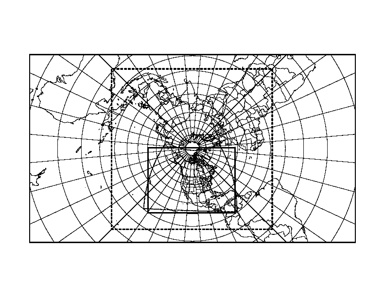
The model is so named because it uses a "nesting" scheme in its grid patterns, putting small grids inside larger ones for particular areas of interest. This model looks at the atmosphere as having 16 vertical levels ("sigma" level) with three nested grids, the innermost grid resolution approximately 80 km over North America. The graphic on the right shows a sample schematic of how the nesting of the grids is structured. The dashed grid represents a size of 160 km, while the dotted grid represents an inner grid of 80 km. |
 |
|
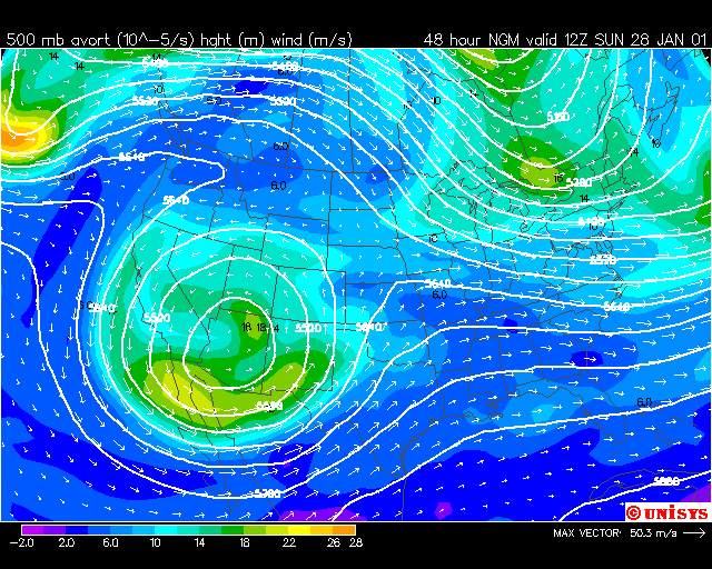
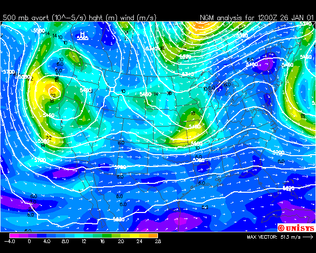
A good source for NGM model data is our old friend, Unisys weather and their NGM Model data page (the University of Wyoming has a good "design-your-own" resource page). We obtained this chart on the right, an image of the 500-mb level projected out 48 hours from Friday, January 26th. If you click on the image on the right, you will be presented with a full-screen, still image 48 hours from 1200Z on January 26. You can also look at this graphic as a "loop" graphic, showing the change at the 500-mb level beginning at 1200Z (8:00 am EST) on January 26th, progressing until 1200Z on January 28th. This particular animation shows the absolute vorticity and the heights at the 500-mb level, as well as the wind velocities at that pressure level. Areas of high absolute vorticities (14x10-5 /m, for example) represent areas that are good locations for some type of severe storm activity. |
|
Another interesting source of NGM products (mostly archived data is available at one of the NOAA sites.
Output for NGM models is often described as "NGM MOS", where MOS stands for Model Output Statistics. This method generates mathematical formulas, or algorithms, that allow the meteorologist to "convert" raw data into predictions or forecasts that are "corrected" mathematically, often based on years of historical weather data. These corrections are specific to a location.
(NOTE! if you recall from an earlier reading, you can use the
MOS regresssion calculator to predict the minimum temperature for a given location.)
For the motivated student, a brief tutorial on how to interpret NGM MOS text-based output is provided for you. If you go to a site such as Wyoming's NGM Model Output Statistics for Individual Stations and choose "text encoded". Click on a station on the map, or enter the three-letter code for the station identifier (Note! This is a large file containing links to all of the stations in the United States. If you are on a slow modem, you might wish to use NOAA's Station Identifier Search Engine).
The NGM model is currently being "phased out" by organizations such as NCEP, in favor of other models such as the Eta model (described in the next reading).
Confused? Have a question? If so, check out the Frequently Asked Questions (FAQ) page or send mail to the OS411 tutor (os411tutor@shodor.org) with your question!
Report technical/content problems here
|
|