| |
|
Domain and Grid Resolution
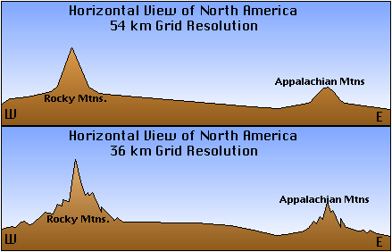
| Domain and grid resolution refers to the breadth and depth of the data to be collected for use in the model, as well as the size of the modeling area. The graphic at right (click to see full-sized) shows an example of resolution. Notice that with the higher resolution (56 km), we see significantly less detail, especially on the slopes of the mountains. You should recall, or recognize if you have not studied computer modeling (computational science), that the computational expense of an increase from 54 km to 36 km resolution is substantial. |

|

|
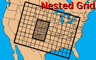
If you recall from the readings in the meteorology course, most atmospheric models use a grid scheme to define the modeling area. Grids are simply overlays onto a region or terrain that show the modeling area and the amount of resolution of each of the grids, or boxes, in the modeling area. The graphic at left (click to see full-sized) shows an example of a nested grid, such as might be found in a meteorological model such as the Nested Grid Model (NGM). |
Perhaps the best way to illustrate the significance of domain and resolution is with a table taken from a current atmospheric science model. This table, from the GSFC NASA ISLSCP model, gives a layout of the type of data fields, the domain over which those data fields must come, and the resolution (both spatial -- in two- or three-dimensional space -- and temporal -- over what period of time).
| Data Fields |
Domain |
Spatial Resolution |
Temporal Resolution |
| Vegetation |
Regional and global |
50x50 km to 1x1 km |
Monthly |
| Near-surface meteorology |
Global |
50x50 km |
Diurnal cycle, monthly means |
| Precipitation |
Global |
100x100 km |
Monthly means and selected days |
| Radiation fluxes |
Global |
250x250 km to 50x50 km |
Diurnal cycles, montly means |
| Soil physics |
Global |
100x100 km to 1x1 km |
Once |
| Topography |
Global |
10x10 km to 1 km or better |
Oncey |
| Runoff |
Regional to global |
Catchment grid formats 50x50 km |
Monthly |
| Snow and ice |
Regional and global |
25x25 km |
Monthly |
Four-Dimensional Data Assimilation (FDDA, 4DDA)
Before getting out of this topic, we should mention four-dimensional data assimilation (4DDA). FDDA refers to the distribution of data over space and time. FDDA is a recent development in modeling techniques, but is not itself a model. The four dimensions in FDDA are the three spatial dimensions and time. Basically, FDDA is a method of inserting observed data into the model at the correct time step while the model is running. A direct insertion causes the model to go into what is called "shock", and is generally bad for any model. So FDDA eases the observed data into the model by "nudging" the data into the correct location and time. This nudging is done by slowly changing the model's values for that location, so that the observed data can be assimilated, or inserted, into the model.
You should recall from your study of computational science that numerical simulations are very sensitive to their initial conditions. The smallest inaccuracy in the initial conditions can cause a drastic departure from the actual state. Fortunately, for the 4DDA, a new observational data set arrives every six hours. Therefore, it is possible to monitor the data over time and modify it in a dynamically consistent way by comparing the calculated results with the actual measurements. Otherwise, the fluctuations in the data set over time will greatly decrease the accuracy of the analysis and result into chaos. This modification to obtain a suitable data set for model initializations is referred to as data assimilation.
Confused? Have a question? If so, check out the Frequently Asked Questions (FAQ) page or send mail to the OS411 tutor (os411tutor@shodor.org) with your question!
Report technical/content problems here
|
|