| |
|
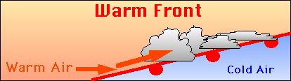
Warm Fronts
A warm front is the boundary zone between retreating cold air and the advancing warm air. Again, the warm air overrides the cooler air, forming clouds and precipitation. However, the weather is characterized by rain or showers, not storms. Because the slope of the warm front is not as steep as the cold front, showers form more gradually, preventing latent energy from reaching high altitudes. There is a temperature and humidity increase with the passage of a warm front.
 As with cold fronts, warm fronts have specific weather patterns associated with them:
| Weather Element |
Before passing |
While passing |
After passing |
| Winds |
South or southeast |
Variable |
South or southwest |
| Temperature |
Cool to cold, slow warming |
Steady rise |
Warmer, then steady |
| Pressure |
Usually falling |
Leveling off |
Slight rise, followed by fall |
| Clouds |
In this order: cirrus, cirrostratus, altostratus, nimbostratus, stratus,
and fog; occasionally cumulonimbus in summer |
Stratus type |
Clearing with scattered stratocumulus; occasionally cumulonimbus in summer |
| Precipitation |
Light to moderate rain, snow, sleet, or drizzle |
Drizzle or none |
Usually none; sometimes light rain or showers |
| Visibility |
Poor |
Poor, but improving |
Fair in haze |
| Dew point |
Steady rise |
Steady |
Rise, then steady |
Confused? Have a question? If so, check out the Frequently Asked Questions (FAQ) page or send mail to the OS411 tutor (os411tutor@shodor.org) with your question!
Report technical/content problems here
|
|