|
|
Satellites
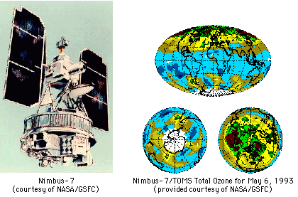
The main meteorological satellite is the "geostationary operational environmental satellite", or GOES. These satellites operate on a west-east orbit at a height of 22,238 miles above the Earth. There are several "types" of GOES satellites: GOES 9 is located at 1350 west longitude over the equator; GOES-8 is located at 7.50 west longitude over the equator; and GOES-10 is located at 00 west longitude over the equator. The term "geostationary" comes from the fact that the orbital speed of the satellite matches the rotational speed of the Earth, keeping the satellite "stationary". Polar satellites, such as NOAA's "TIROS" (Television Infrared Observation Satellite) orbit over the North and South Poles, roughly 500 miles above the Earth. These satellites perform a number of functions, including supplying meteorological data (particularly upper-air temperature data) to areas without radiosondes or other data-collection devices. In reference to weather and air quality, satellites are not limited to taking photographs and collecting meteorological data. They can actually measure and monitor air quality for us. Until December of 1994 the Nimbus-7 and Meteor-3 satellites used TOMS (Total Ozone Mapping Spectrometer) instrumentation to measure ozone in the stratosphere and upper troposphere. In addition to ozone, satellites are being used to measure carbon dioxide levels and can be used to measure practically any pollutant we care to invest the funds to measure.
 Satellites can provide us with a tremendous amount of data that can aid us in our efforts to warn people who are in the path of immediate dangerous weather systems or alert the public to possible threatening climatological change. The air quality data that satellites collect can assist air quality modelers with their assessment of the air so that, if necessary, appropriate legislation can be introduced to restrict what we put into our environment. Confused? Have a question? If so, check out the Frequently Asked Questions (FAQ) page or send mail to the OS411 tutor (os411tutor@shodor.org) with your question! Report technical/content problems here |
|
|
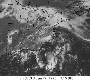 While radar technology can provide us with a view of a localized cross section of the atmosphere, satellites in orbit above the earth can beam down photos of the entire globe. How much more fascinating can it get than to watch nearly live (we receive satellite imagery every 15 minutes) top view footage of a hurricane as it forms and sweeps across the ocean before striking the coast. Satellites have become an invaluable tool for forecasting the weather. Not only can satellites take photographs, they also function as sensing devices. Satellites can measure radiation from the earth's surface and atmosphere which can help us make determinations about the earth-atmosphere heat budget. They can measure water vapor content in the air and even measure winds. Satellites can collect, compile, and transmit data from remote surface stations making data collection and organization an easier task.